
Last year, the Kongsvinger municipality received funding from the Norwegian Environment Agency to map peatlands in the municipality in a project together with the Inland Norway University of Applied Sciences.
There is great potential for reducing greenhouse gas emissions through municipal planning, among other things by taking care of carbon-rich areas and facilitating climate-friendly development.
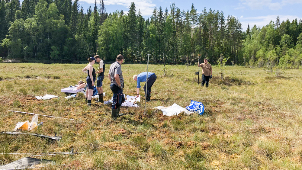
Extensive fieldwork was initiated on peatlands in the Kongsvinger area, in which five students from INN played key roles. The aim was, among other things, to gain more knowledge about the amount of carbon stored there.
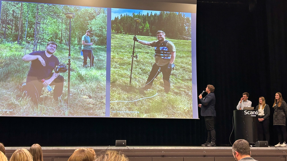
At the recently held Nature and Climate Conference in Hamar, project manager Kjersti Enger Dybendal from the Kongsvinger municipality and students shared their preliminary findings.
Exciting field work
In the summer of 2023 extensive field work was carried out. The students at INN mapped the vegetation, measured peat depths, and collected peat samples.
The work used technology such as drones and ground-penetrating radar (georadar), and manual methods such as peat samplers and Russian Peat Borer. The students were given access to three drones and certified as drone pilots through the Norwegian Aviation Authority, with the INN university as the drone operator.
And the students' summer job was diverse.
Sondre Englund Brenni is a master's student at Evenstad and was mainly responsible for the vegetation mapping. He has studied the vegetation on the peatlands, and assessed whether they were nutrient-poor or nutrient-rich.
Martin Eilertsen is a bachelor's student at Blæstad and has had the main responsibility for land surveying and setting up the grid on the peatlands. For the work, he used an RTK, which is a very accurate satellite-based GPS tool, and drone images to plan the most optimal layout of the grid.
Anne Petra Øyen Jacobsen is a bachelor's student at Evenstad and, together with Siri Graff, has been responsible for the georadar, which is an instrument used to measure the peat depth.
Kasper Tollefsbøl is a bachelor's student at Evenstad and had the main responsibility for equipment in addition to being the fieldwork's handyman.
Mona Bakke Myrvang and Peder Lombnæs work at the Department of Agricultural Sciences at Blæstad. They are both associate professors and were responsible for the fieldwork part of the project.
– At the most challenging peat samplings, Kasper and Martin's strength was invaluable, says Myrvang.
9000-year-old Peat!
There is a lot of equipment that is used when a peatland is to be surveyed.
A Peat Sampler consisting of meter-long extendable probes was used to manually measure the peat depths. The peat sticks were used to calibrate the georadar, i.e. ensuring that measured peat depths match.
At least at three strategic points on the peatland, peat samples were taken for every half meter down to three meters using a so-called Russian Peat Borer. A Russian Peat Borer is a type of hollow cylindrical sampler that can retrieve intact peat samples from specific depths.
– Roughly speaking, you could see that the grade of decomposition of peat increased the deeper you went. But this was not always the case, says Mona Bakke Myrvang.
At one location, the students found a completely intact peat moss at a depth of 3.5 meters which turned out to be an Austin's sphagnum moss, Sphagnum austinii. Roughly speaking, one can say that intact peatland accumulates approximately 1 mm a year.
– Perhaps this Austin's sphagnum moss is as much as 3,500 years old? The deepest peatlands, such as Fløytmyra, turned out to be at least 8-9 meters deep towards the middle. This means that peat at the bottom of Fløytmyra probably originates from the early post-ice age period here in Norway, says Myrvang.
Altogether, nearly 300 peat samples were taken, which will be analysed at the soil laboratory at Blæstad.
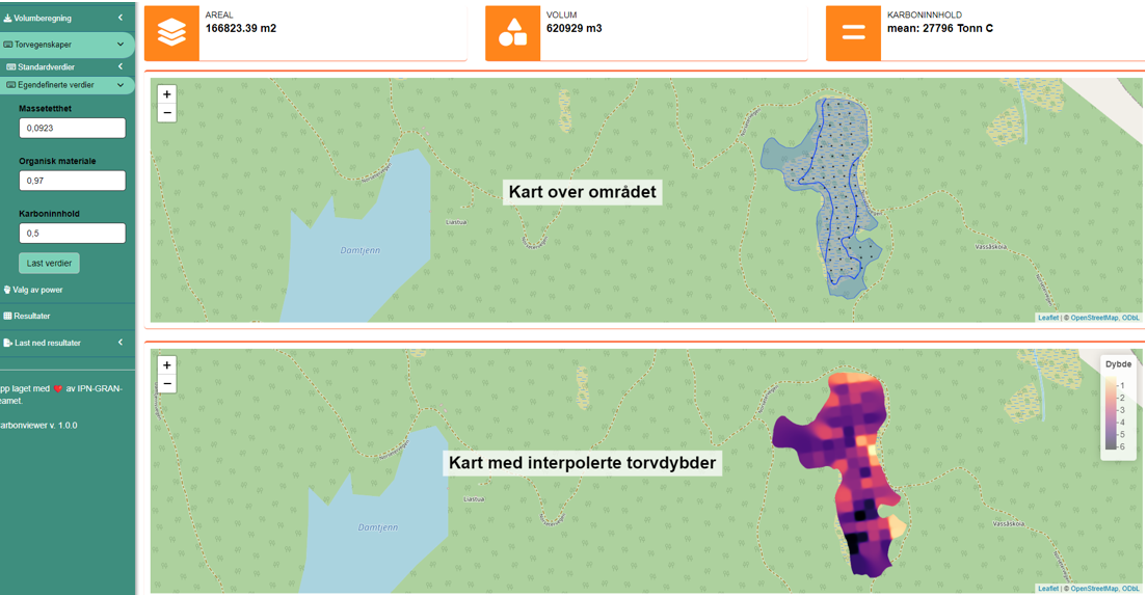
In the post-work, a carbon calculator tool called CarbonViewer is used. CarbonViewer is an application developed by the Norwegian Institute for Nature Research (NINA) in collaboration with the Norwegian University of Science and Technology (NTNU).
INN has been in close dialogue with the developers of the calculator in the planning phase of the field work with the thought of using the tool in the follow-up work. CarbonViewer uses data from both maps and point-measured GPS-fixed peat depths to calculate a three-dimensional model of the peatland. The application also needs soil test values for mass density and ignition loss. With these values, the calculator can estimate both the peat volume and the carbon content.
First results are ready
At the Nature and Climate Conference, the students together with Kongsvinger municipality presented the fieldwork they carried out and preliminary results.
Most of the peatlands included in the project were generally found to be nutrient-poor precipitation-fed peatlands. This means that they get their nutrients mainly through rainwater. But you could often see that parts of the peatland showed more influence from groundwater inflow, which makes the peatland more nutritious and thus gets a different flora.
The georadar proved to be a very effective tool for peat depth measurements and enabled the students to map far more peatlands than if they had only used peat samplers.
– The first results are now ready for a peatland called Rafjellsmyra. This is a peatland of 167 decare, which we have now managed to calculate to a volume of approximately 621,000 m3, and with an estimated carbon content of almost 28,000 tons. Converted to CO2 equivalents, this carbon content is equivalent to storing to almost twice the carbon emitted annually by the entire Kongsvinger municipality, says Mona Bakke Myrvang.
The results from field work and laboratory work will provide Kongsvinger municipality with useful knowledge about the potential greenhouse gas emissions in the examined peatlands.
When this information can be implemented in maps, it will help decision-makers in the municipality to make informed decisions with regard to land use changes that affect peatlands.
– It is important to note that the demarcation of the peatland has been done ahead of the field survey based on existing maps. What we have observed in the field is that the map does not always agree with the terrain, and the peatlands can potentially be much larger than what appears on the map, says Myrvang.
From the INN university's side, the research part of the project linked to carbon in the peatlands has been important, and two of the INN students have decided to explore some of the issues further in their master's and bachelor's theses.
The project managers for the field work, Mona and Peder, are currently working on a technical report that the municipality will receive. In addition, there are plans for a publication during 2024/2025.
– The project has been exciting and educational for both the municipality and the INN university, and we will continue to have a close collaboration in the future as well, says Mona Bakke Myrvang.
Contact information:

- mona.myrvang@inn.no
- Phone
- +47 61 28 74 20

- peder.lombnas@inn.no
- Phone
- +47 62 43 03 84